 |
|
|
||
|
|
Ulsterheart Chapter 1 (Kilgreen Dawn)
pages 19 through 24
Pages 16 through 18 consist of a comparison of Irish languages.
These were scanned, but are not displayed here
Page 19
So, according to Kelly Groves there were 50 townlands in Kerog. To this we may add for our study 6 others sometimes considered Kerog townlands—Ballinaputtock, Lisbeg, Lisdoart, Lisnabuny, Tullyvar, and Tullywinny. The area now known as Ballynasagart townland is labelled Corballigallie on the 1620 Barony Map. Crossbuoy may have been nothing more than a track intersection in the townland of Feddan in 1620. Kelly Groves spells it Cross-bwee—a more accurate representation of an original gaelic 'buidhe' (yellow) than the latter-day nautical or maritime-sounding 'buoy'.
Tanna Garruc is the 1620 cartographer's name for the area we now call Errigle. Tarn na Garruc would mean Kerog's portion. It is of the highest significance for our later enquiry to note that, as late as the 17th century Kerog's name was still transmitted orally as Garruc.
Conspicuous by their absence from the 1817 list are Bloomhill, Greenhill, Roughhill, Halftown, and Richmond. Clearly, later usage has extended to larger areas names which in 1817 were confined to individual holdings. Bloomhill is really in the townland of Fernamena. Incidentally, Fernamena is apparently the area labelled by the 1620 cartographer with the cryptic Lisne??lart.
Sir John Stewart, moving into the Harvey property of Tully-glush anglicised the name to Greenhill, but on the Map attached to the Shaw Mason Survey only six years later the name Greenhill is associated only with the House and farm within the townland of Tullyglush. Clearly Stewart did not intend the new name to be confined so, since he called his home Ballygawley Park.
Richmond was a development of the name Richmount (apparently Richardson's Mount) which the 33 rd Rector called the new home he built in 1780 in the townland called Churchlands. It is
Churchlands on a 1774 Neely stone, and it was still Churchland in 1817, but in 1820 Richmond appears on the Baptism Register. Subsequently these 265 acres do not appear to have got the name Churchland. But Churchland is an English word, and so it is surely of recent vintage. Since it is contiguous with Grange these 265 acres were almost certainly part of the Moy Enyr Granary. A Findrum farmer still calls one field "Churchlands".
On the analogy of this connotation extension it is probable that two Gaelic townland names in the 1858 Griffith Survey were farm names in 1817. Drumnamalta and Knockbrack were probably residences in Gort and Glencul respectively. Indeed, as late as 1860 Martha Speer owned 96 out of the 112 acres in Drumnamalta, and Mary Neely owned all 87 acres of Knockbrack. Perhaps it would be fanciful to suggest any connection between the popular nickname for the round hillock south of the entrance to the Gort Road "Whiskey Hill' and the last syllable of DrumnaMALTA.
Roughhill and Halftown comprised in 1620 the single town-land of Lissarlonan. Halftown is almost exactly half the area of the townland once called Lisarlonan. Lisarlonan (Bullock-Fort) may easily have got its name from the strange enclosure in the centre of Roughhill.
Tatecosker is the name of an area adjacent to Culligary in the 1620 Map. It may well have been the original name of Martray Manor. The Hamiltons certainly had a residence there in Elizabethan times, and a footnote to one of the 17th century surveys says Archibald Hamilton had a Bawn 16 feet by 312 feet at Tatecosker in 1628. A tate or tatty is an area of about 60 acres. Cos-Ker means Forest Fort. Incidentally all three who recently removed one half of the fort suffered undiagnosed demise.
Finally the cryptic Cavanaslourt of the 17th century lists is not easily located today. The 17th century surveys list townlands in fairly geographical sequence. So when Cavanaslourt appears between Findrum and Lisgonel we may tentatively suggest it was the name of a hamlet in the vicinity of Lisgonel School and Knockony House. This might account for the regular Fair or Market held at Killymorgan.
From the pretexts and trends for local nomenclature which have emerged it might just be possible to ascertain the original areas
before nicknaming and specification spawned more than fifty. Traditionally there were 'nine towns of Errigle', but it may be pure co-incidence that the townlands which have preserved patently Brittonic roots number exactly nine
| BallyLAGEN | Errigle | Lettery |
| Clonully | Glencul | Roughan |
| Crew | Killymorgan | Cosker |
They preserve unique clues to the Boyne culture of the Ulsterheart for more than two millennia before a.d. 330. One placename reflects their beliefs—Kilgreen. Irish places with the syllable 'green' in their names are no greener than others in an island emerald from Adantic spray. So the name Kilgreen does not refer to local colour. 'Green' is an anglicizing of 'grian' the Gaelic word for 'sun'. Kilgreen means 'Church of the Sun'.
Today there are two Kilgreens. One of them, subject to local tax (sess)-Sesskilgreen is separated from the other by Glencul which underlines the possibility that the name Glencul may represent an original Llan-haul the exact Brittonic equivalent for Kilgreen. The Neely mound above the Waterside looks ominously like the original church of the sun. But the cult was widespread, and Kerog is flanked by CavanKILGREEN and BallyGREENan.
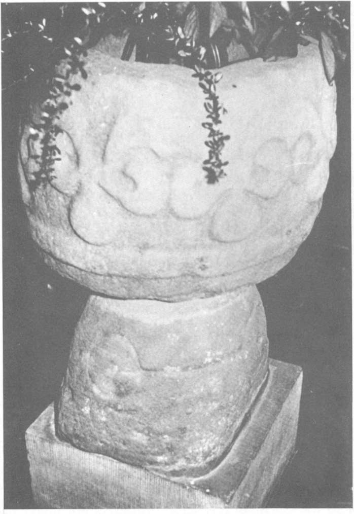
Prior to the Christian revelation primitives got pretty near to the truth by simple observation. They noticed that light induces growth and vitality. Their next step was to credit the solar disc with the origin of all. How our predecessors in the Ulsterheart worshipped the sun we may never discover, but at least one of their utensils has survived. The Kilgreen Bowl is preserved in Kerog Church. Its cryptic motif engraved perhaps 30 centuries ago seems vaguely astronomical. Was it some primitive attempt to chart a constellation? Or does it in some way represent the continuity of life from its source on high, through the common round, with shifting centres, even to the depths?
|
Small wonder that they venerated lower agents of vitality. A pillar in the custody of Thomas McKenna has distinctly phallic features. And the Prince's Chair, with its barely discernible circles may also date from Clonully days.
And so the oudines of Clonully life emerge from the Ulsterheart of 300 a.d. in the rays of the Kilgreen dawn.
For six centuries now, since 300 b.c., Kerog, Ulster, and Ireland had been well populated by the Early Irish. But during those
 |
centuries something had happened which was to affect their life for millennia to come. Some mysterious convulsion in the valleys of the upper Danube and Rhine sent the Gaels gyrating in all directions. They ran berserk into the Balkans, Italy, France, and Spain.
About 56 a.d. the great missionary Paul wrote to the "stupid Galatians" he found in Turkey (Gal.3,1). Some claim that these Gaels were the first nation in the world to become Christian, but their subsequent vacillation exasperated Paul, hence the epithet 'anoeetoi' literally 'mindless'. One of their chief settlements on Paul's itinerary had a conspicuously Gaelic name LISTRA (the fort on the strand). On the first of his four visits the language barrier caused a communications gap, with almost fatal consequences. They mistook him for the heavenly messenger Hermes. When Paul disillusioned them the reaction set in, and he was nearly killed.7
Fifty years before Christ was born, Julius Caesar disturbed many Celtic tribes during his conquest of Gaul.8 Indeed, the nearest they ever got to forming a Celtic nation was aborted by "the greatest Roman of them all".
Dislodged from the Durance Valley in the high Alps, the Cairidi escaped to the Bordeaux coast, and then sailed direct to Kenmare. The earlier Irish called these newcomers 'Goidils' a Brittonic word which eventually displaced Cairidi as their tribal designation.9
The original Irish withdrew northwards, or were trapped in the peninsulas where pockets survived intact in the Gaelic rear for long enough to establish placenames like Moy Ulaid in Dingle and Cruit off Donegall.10 The Gaelic invasion was held up for many years on a line from Boderg to the Boyne. When this line was pierced the older Irish constructed a rampart across the neck of Ireland from Dundalk Bay to Donegal Bay. This early Irish border between the incoming Gaels and the older Irish protected Emaen the Ulster capital until 330 a.d. As Professor Beckett says "In spite of their iron weapons they made a very slow conquest, and the pre-Gaelic population, especially in the north, long retained its independence."