|
Griffith's Valuation for Armaloughy Townland (Image below)
Map showing Armaloughy Townland within larger maps of Northern Ireland
Map showing farm of Andrew McFarland within the townland Armaloughy
Modifications of tenancy in 1931 (CD or DVD only)
|
No. and Letters of Reference to Map |
Names | Description of Tenement |
Area
|
Rateable Annual Valuation Ł (pounds) s (shillings) d (pence) |
Total Annual Valuation of Rateable Property |
||
| Townlands and Occupiers | Immediate Lessors | Land | Buildings | ||||
| ARMALUGHEY | A. R. P. | Ł s d. | Ł s d. | Ł s d. | |||
|
(Ord. S. 53 & 60) Map reference |
|||||||
| 1 | John Wigam | Thomas Mann | House and Land | 8 0 20 | 6 10 0 | 0 10 0 | 7 0 0 |
| 2 | Patrick Rogers | ...same... | House, offices and Land | 11 1 25 | 8 15 0 | 0 15 0 | 2 10 0 |
| 3 | William Bell | ...same... | Land | 3 1 30 | 2 15 0 | 2 15 0 | |
| 4 A | Andrew Wigam | ...same... | Land | 9 2 20 | 7 15 0 | in red below | |
| 4 B | Andrew Wigam | ...same... | Land | 1 3 30 | 1 17 0 | in red below | |
| 4 C | Andrew Wigam | ...same... | House, offices, and Land | 10 1 26 | 9 10 0 | 1 0 0 | in red below |
| 4 D | Andrew Wigam | ...same... | Land | 3 1 20 | 2 8 0 | in red below | |
| 10 A d | Andrew Wigam | ...same... | Office and garden | 0 0 28 | 0 3 0 | 0 5 0 | 23 0 0 |
| 4 A a | John Conner | Andrew Wigam | House | 0 5 0 | 0 5 0 | ||
| B a | School house | (see exemptions) | |||||
| 5 | John Boyd | Thomas Mann | Land | 4 1 0 | 3 5 0 | 3 5 0 | |
| 6 | Thomas Beatty | ....same... | Land | 5 2 0 | 2 0 0 | 2 0 0 | |
| 7 A | Margaret Hopper | ...same... | House, offices, and land | 3 1 30 | 1 15 0 | in red below | |
| 7 B | Margaret Hopper | ...same... | House, offices, and land | 1 1 20 | 51 10 0 | 3 10 0 | in red below |
| 10 A c | Margaret Hopper | ...same... | House, offices, and land | 0 0 20 | 0 5 0 | 57 0 0 | |
| 8 A | James Hopper | ...same... | House, offices, and land | 1 3 0 | 1 5 0 | in red below | |
| 8 B | James Hopper | ...same... | House, offices, and land | 2 0 5 | 1 17 0 | in red below | |
| 8 C | James Hopper | ...same... | House, offices, and land | 7 0 20 | 5 10 0 | in red below | |
| 8 D | James Hopper | ...same... | House, offices, and land | 11 1 25 | 7 8 0 | 1 5 0 | in red below |
| 10 A c | James Hopper | ...same... | House, offices, and land | 0 0 12 | 17 5 0 | ||
| 9 A | Thomas Hopper | ...same... | House, offices, and land | 16 0 35 | 12 10 0 | in red below | in red below |
| 9 B | Thomas Hopper | ...same... | House, offices, and land | 1 3 10 | 0 15 10 | 1 5 0 | 14 10 0 |
| 10 A a | Samuel Wigam | ...same... | Ho, off, labs, bc & land | 22 2 15 | 19 0 0 | 1 15 0 | in red below |
| 10 B | Samuel Wigam | ...same... | Ho, off, labs, bc & land | 0 2 10 | 0 10 0 | 21 5 0 | |
| - b | Lydia Boyd | Samuel Wigam | House | 0 5 0 | 0 5 0 | ||
| - f | Ann Boylan | James Hopper | House | 0 5 0 | 0 5 0 | ||
| - g | John M. Kew | ...same... | House | 0 5 0 | 0 5 0 | ||
| 11 | Alexander Downes | Thomas Mann | House, offices, and land | 12 1 35 | 9 0 0 | 1 10 0 | 10 10 0 |
| 12 | Andrew M ' Farlane | ....same... | House, offices, and land | 47 1 30 | 31 10 0 | 2 10 0 | 34 0 0 |
| Total Rateable Property | 253 2 36 | 187 15 0 | 15 5 0 | 203 0 0 | |||
Entry in Townland INISHMAGH, also Carnteel Parish, for John Sadleir
|
No. and Letters of Reference to Map |
Names | Description of Tenement |
Area
|
Rateable Annual Valuation Ł (pounds) s (shillings) d (pence) |
Total Annual Valuation of Rateable Property |
||
| Townlands and Occupiers | Immediate Lessors | Land | Buildings | ||||
| INISHMAGH | A. R. P. | Ł s d. | Ł s d. | Ł s d. | |||
| (Ord. S. 53) | |||||||
|
5c |
John Sadleir | Sir Wm. Verner, Bart. | House and Garden | 0 1 0 | 0 5 0 | 5 0 0 | 5 5 0 |
The first above table transcribes the valuation table for Armaloughey Townland in the image below (printing date 1860).
The table below transcribes an 1821 court record certifying that Andrew McFarland leases the above 47-acre farm.
Two other people are named in the lease agreement. This record is part of a larger record covering Armaloughy Townland
which is available through the Mormon Church.
The image below is transcribed by the table above. The image was trucated; click on the image to see original.
In 1873 Andrew McFarland took over the farm #11 of Alexander Downes, Number on map , Acres , Roods , Perches
(11 ; 12 ; 1; 35 ; Paying Ł10 – 10 - 00 per annum)
In 1879 the farms were combined paying Ł44 – 10 –00 per annum. In 1885 they were split and No11 changed to
William Williamson and No 12 remained in Andrew McFarland’s name. No12 remained in Andrews name until he died in 1893
when it changed to M. J. Fiddis he was replaced by James & Patrick McKenna in 1913. As of 2017, the farm is
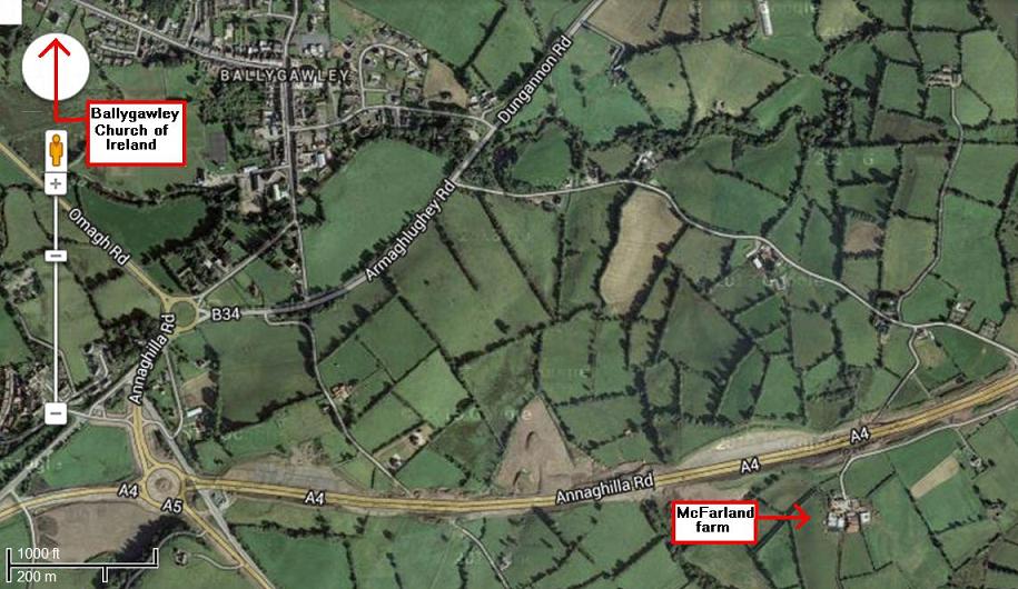
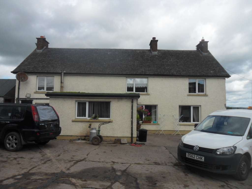
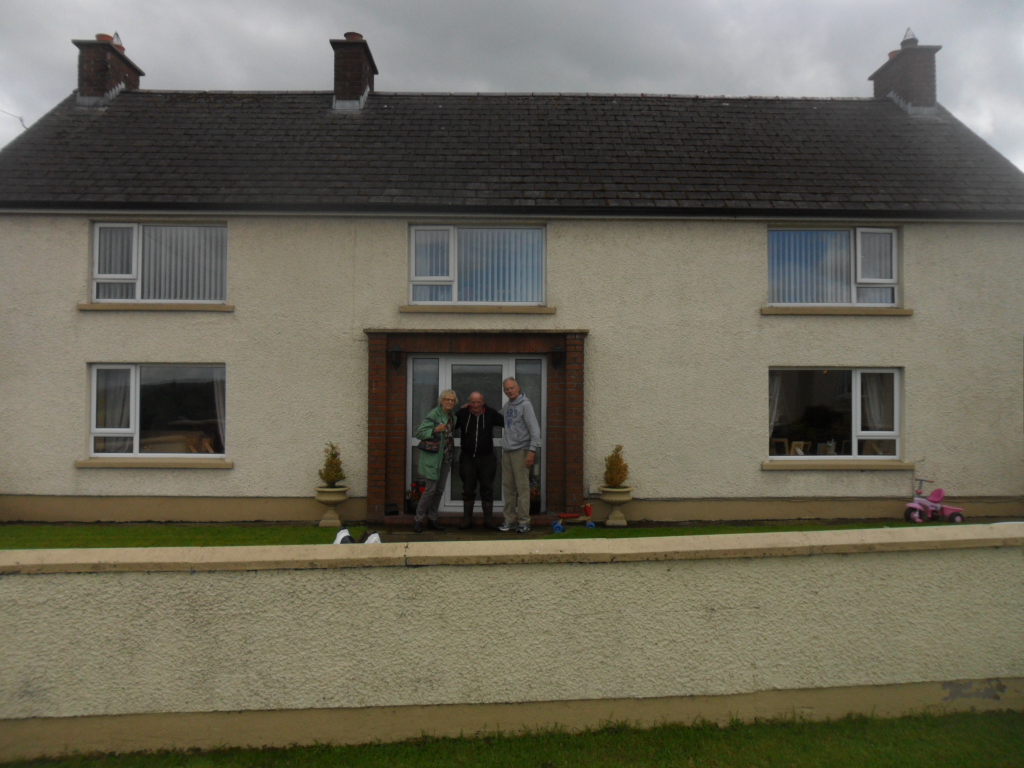
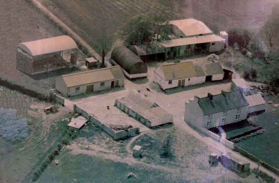
owned by Oliver Cootes, age about 75, and his son; Tom McFarland met Oliver at his house on 14 August 2017.
Oliver remembered that his farm was once owned by McFarland (see photos below).
Number 3 on map (not copied below) ; Acres ; Roods ; Perches (3 ; 3 ; 1 ; 30 ; Paying Ł2 – 15 - 00 per annum)
Adam Bell held farm #3 as of about 1860. He was replaced by Mary Bell in 1882 in 1889, she was replaced by Robert McFarland.
The 1930 property records show that farm #3 was still owned by Robert McFarland.

No. on Map
No.
Denominations
Tenants' Names
Quantity of land in statute measure
Quantity in late Irish plantation measure
Yearly rent and rent charge
Gale days
Tenants' tenure
23
12
same
Andrew McFarland
A.
47
R.
0
P.
30
A.
29
R.
0
P.
21
Ł
10
s.
7
d.
7
1st May and 1st Nov
Lease from Sir John Stewart, Bart., to Andrew McFarland, dated 2nd November 1821,
for lives of lessee, James McFarland, and
Mervyn Stewart Wilson (all still living).
Covenant for perpetual renewal on payment of 1s. fine on fall of each life. Lease reserves to
lessor all mines, minerals, timber, and royalties, and reserves to lessee a right of Turbary on
Bog of Ballymackilroy (Lot 9, second division). Ł10 late currency yearly rent reserved.

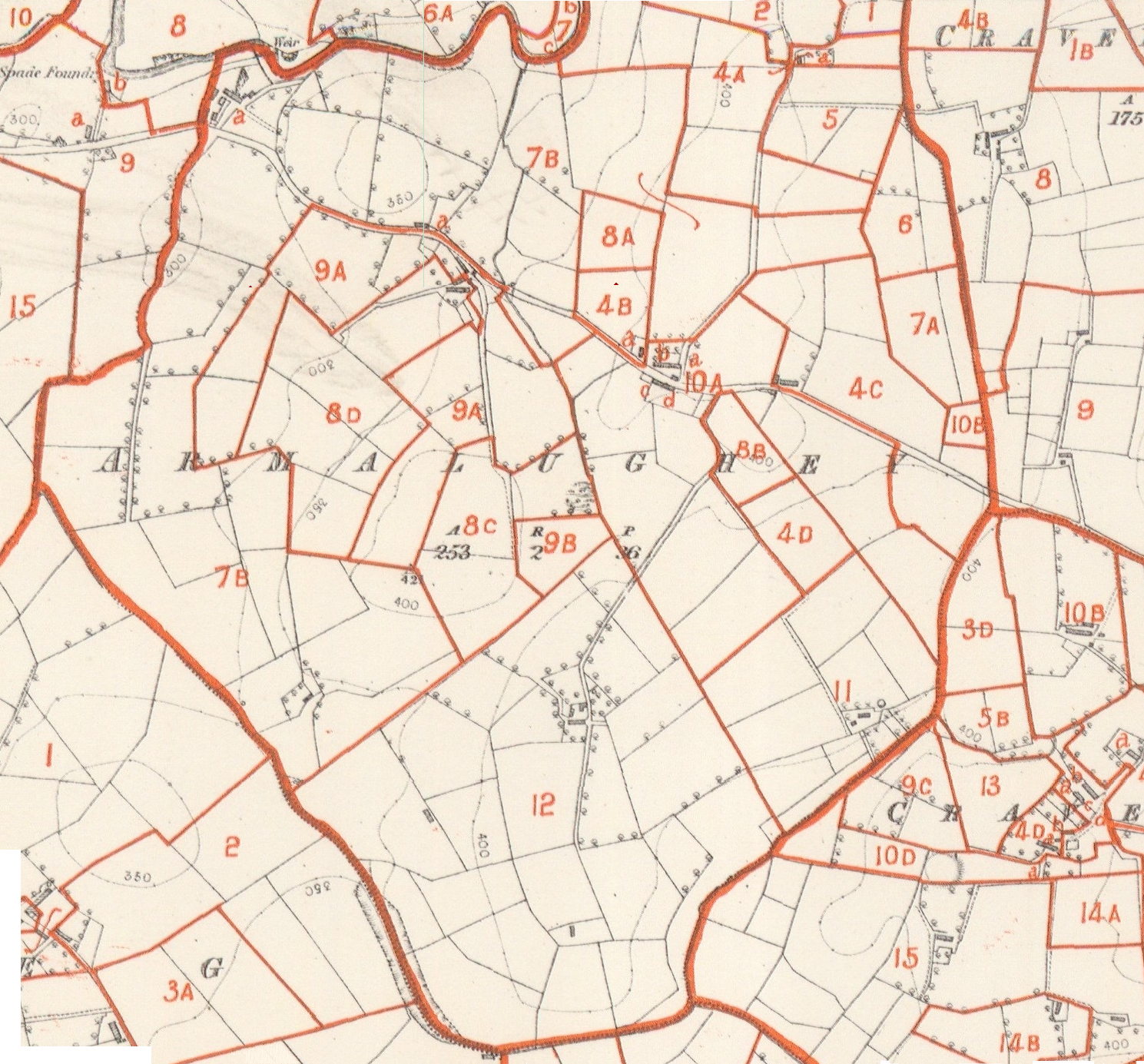
The Ordnance Survey Map of Armaloughey is below, showing the farm and buildings
of Andrew McFarland (born 1790) as plot number 12 at the lower edge. The map is about a half-mile
across and shows (faint) elevation contours. The brown numbers correspond to property
residents named in the Griffith's Valuation above. The village of Ballygawley is just off the upper left corner of this map.
Roads shown on this map are also shown on more recent maps in 2008.
To see a (6 MB) more detailed image, click on the image below,
or click here.
This map was downloaded free from www.Irishorigins.com, but the
procedures at this website would make it more difficult to download after 2012.
Revised Valuations Armalughey: these records note changes in acreages or occupiers and map numberings.
held by Andrew McFarland leasing from Thomas Mann. C1860 in the Townland of Armalughey Parish of Carnteel;
Ordnance Survey Map O.S.53 & 60: number on map . Acres , Roods , Perches (12; 4; 7; 1; 30; Paying Ł34 per annum)
The map below is on non-circulating microfiche (6341637) at the Mormon Family History
Library in Salt Lake City.
The maps above and below cover roughly the same land.
Color was added below to emphacize certain features.

The modern satellite image is below (from Google , 2011) .
Roads on the two maps (above and below) are mostly identical.
However, in 2011, the A4 highway was re-located southward and
now comes very close to the McFarland farm. This image is just
off the upper left corner in the following link to Google maps:
Zoom-able Satellite photo
alternate access to above photos
{A} is original 1850 home, currently well-maintained.
[B] is newer home used by the son of the current owner
[C} are buildings removed for new construction seen below
[D] is l;ocation of camera for first photo below