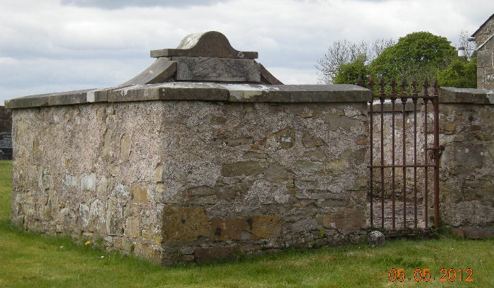
This burial plot was up-graded in June 2018 upon request of Tom McFarland. The up-grade included cleaning the
headstone, adding the names of family members presumed to be buried in the plot, replacing the cracked concrete floor
with more attractive tiles, re-painting the iron gate, and cleaning the loose headstone which had been lying within the walls.
|
|
|
Above photo taken 2012, before upgrade ↵ photo below taken in 2018 after upgrade ↴ |
|
|
|

original lettering in black; lettering added in 2018 in red
ANDREW McFARLAND
of Ardmaloughy who departed
this life March 9th 1857 aged 67
also his daughter ELIZA who
died March 29th 1837 aged 23
HIS WIFE MARTHA
THEIR SON ANDREW II 1830 --12 / 07 / 1893
ANDREW II's WIFE ANASTASIA
BORN 22 / 09 / 1837 DIED 20 / 06 / 1891
THEIR GRANDCHILDREN
ANDREW JOHN (1863-1864)
ANDREW JOHN (1869-1875)
SOPHIA (1875-1875)
For here we have no
continuing city, but we seek
one to come , Heb 13: 14
|
|
Carol Conlin, at the Armagh Public Library, 30 km southeast of Ballygawley, was asked to comment on the word "Ardmaloughy" in the above inscription,
which also appears on the marriage registration for Catherine McFarland. She writes:
"Armalughey in Irish is 'ard maol Eachadha' and means Eoghy's bare hill.
We can find no trace of 'Ardmaloughy' and wonder if there has been a mix of Irish and English in the spelling on the headstone."
Armaloughy (or Armalughey) is an Irish townland a mile east of Ballygawley. We know from birth registrations and
Griffiths Valuation that the family of Andrew McFarland lived at the south tip of Armaloughy from before 1864 to after 1874. |
Exterior of family plot for Andrew McFarland
The Ballygawley COI is about 10 meters to the right
Photo dated 2012 courtesy of Evelynn Cartwright
 |
|
Interior of family burial plot for Andrew McFarland, upper photo by Evelynn Cartwright from 2012, the lower two from church official Joyce Edwards in 2018.
The 2nd (broken) headstone remembers Anne Coulter, who is not known (in 2018) to be related to Andrew McFarland, but such a relationship may exist,
so the loose headstone will remain within the walls. This writer (Tom McFarland in 2018, with little supporting evidence) will speculate that the Coulter
headstone originally laid flat on this burial plot in 1837 before the walls were built. Then two months later, Andrew McFarland buried a daughter Eliza nearby,
either without a headstone or with a stone which is lost. When Andrew himself died in 1857, his widow Martha erected the current walls with headstone
memorial to her husband and Eliza, but in moving Anne's headstone, it broke. |
|
|
|
Above photo taken 2012, before upgrade ↵ photos below taken by Joyce Edwards in 2018 after upgrade ↴ |
|
|
| |
Loose headstone at left above is magnified below
SACRED TO THE MEMORY OF
ANNE COULTER
WHO DEPARTED THIS LIFE ON
THE 19 JANUARY 1837
aged 38 years |
|
|
| |
|
Headstone of Archibald McCaughan, husband of Mary McFarland
Inscription: In memory of Archibald McCaughan of Grange who departed
this life May 26th 1897 aged 75 years. Erected by his loving wife MARY.
Mary is likely also buried here, but she is not named on the headstone.
Family plot for Andrew McFarland (Mary's father) visible rear left
and the east wall of the church is to the right.
This headstone is visible in the church photo below
Above photo courtesy of Evelynn Cartwright |
|
|
|
McFarland plot is just off the left edge of this photo |
|
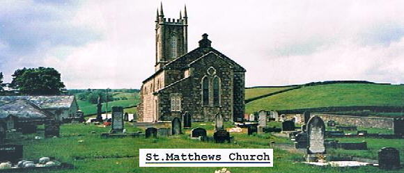
Alternate possible gravesite: St. Matthew's Church
|
|
|
Evelynn Cartwright describes this church
The above photo is looking (west) at the back of the church across the graveyard. Notice the
stone wall [along] the outside (right) as mentioned in the book Ulsterheart,
made from stones of St. Kerog church when it was demolished in 1832.
Standing [along] the wall at the far back
and up the [right] side are gravestones which cannot be read due to weather. Oh! I wish they could be.
This church is about 2 miles west of Ballygawley. You travel out the A4 toward Augher. About 1 mile
out you take the road to the right and travel about 1 mile? The Old Mill is across from the church.
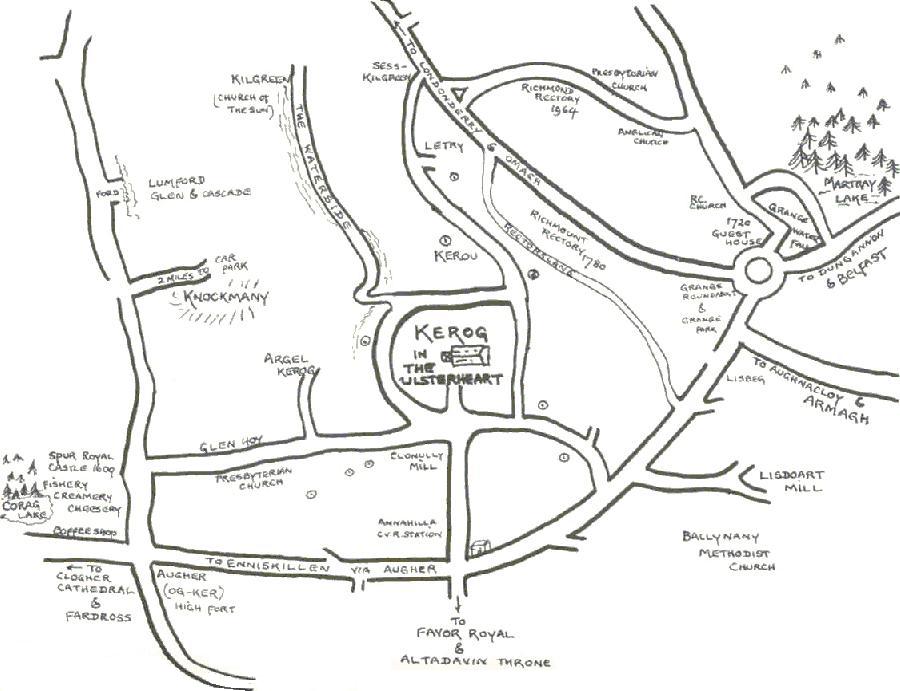
A local map shows the church near the intersection of Glenhoy Rd, Feddan Rd., and Ballynasaggart Rd,
the last road also known as Halftown Road when it crosses the A4. A corresponding map (below) drawn
by the Rev. Brett Ingram in his book Ulsterheart shows the location of the old Kerog church.
which is adjacent to St. Matthew's. To reach the ancient Errigle Cross cemetery, travel west
from St. Matthew's about 1 km on Glenhoy Road, then right about 500m on Errigle Road
(called "Argel Kerog" on the map below): Errigle Cross is 30m south of the road.
A satellite photo of Errigle Cross is also below |
|
|
|
|
|
Above is the ancient Errigle Cross cemetery west of Ballygawley. Also see graves at Killeshil Church of Ireland east of Ballygawley
|